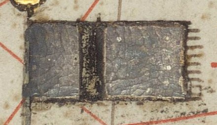
Файл:Delhi Sultanate Flag.svg

Розмір цього попереднього перегляду PNG для вихідного SVG-файлу: 800 × 377 пікселів. Інші роздільності: 320 × 151 пікселів | 640 × 302 пікселів | 1024 × 483 пікселів | 1280 × 604 пікселів | 2560 × 1207 пікселів | 2687 × 1267 пікселів.
Повна роздільність (SVG-файл, номінально 2687 × 1267 пікселів, розмір файлу: 8 КБ)
Історія файлу
Клацніть на дату/час, щоб переглянути, як тоді виглядав файл.
| Дата/час | Мініатюра | Розмір об'єкта | Користувач | Коментар | |
|---|---|---|---|---|---|
| поточний | 15:18, 6 квітня 2024 |  | 2687 × 1267 (8 КБ) | NorthTension | adding transparency |
| 12:20, 2 квітня 2023 |  | 2687 × 1267 (7 КБ) | पाटलिपुत्र | Reverted to version as of 11:00, 4 March 2023 (UTC) The flag in the Catalan Atlas is not green. Check description on the page | |
| 17:01, 1 квітня 2023 |  | 678 × 310 (235 байтів) | 5ysksos6 | Reverted to version as of 21:12, 3 March 2023 (UTC) | |
| 11:00, 4 березня 2023 |  | 2687 × 1267 (7 КБ) | पाटलिपुत्र | Reverted to version as of 04:52, 10 February 2023 (UTC) Fake | |
| 21:12, 3 березня 2023 |  | 678 × 310 (235 байтів) | Shylame | Reverted to version as of 02:28, 10 February 2023 (UTC) It was green in colour | |
| 04:52, 10 лютого 2023 |  | 2687 × 1267 (7 КБ) | पाटलिपुत्र | Reverted to version as of 06:40, 9 February 2023 (UTC) | |
| 02:28, 10 лютого 2023 |  | 678 × 310 (235 байтів) | 5ysksos6 | Reverted to version as of 15:35, 28 June 2021 (UTC), the catalan atlas is from more than 625+ years old, it can be green but decolorated | |
| 06:40, 9 лютого 2023 |  | 2687 × 1267 (7 КБ) | पाटलिपुत्र | borders | |
| 06:25, 9 лютого 2023 |  | 2687 × 1267 (9 КБ) | पाटलिपुत्र | actual flag per source | |
| 09:38, 8 лютого 2023 |  | 2517 × 1256 (581 байтів) | पाटलिपुत्र | Proportions |
Використання файлу
Такі сторінки використовують цей файл:
Глобальне використання файлу
Цей файл використовують такі інші вікі:
- Використання в af.wiki.x.io
- Використання в ar.wiki.x.io
- سلطنة مغول الهند
- فيروز شاه تغلق
- محمد تغلق
- مماليك الهند
- سلطنة دلهي
- علم بنغلاديش
- نظام الدين أولياء
- السلطنة البهمنية
- بيبي ناناكي جي
- تغلق خان
- محمود شاه تغلق
- نصرت شاه تغلق
- خضر خان
- محمد شاه بن فريد خان
- قطب الدين الخلجي
- ناصر الدين خسرو
- بهلول اللودهي
- سكندر بن بهلول اللودهي
- مالك مقبول
- سلطنة البنغال
- قائمة الحروب 1000–1499
- قائمة أعلام باكستان
- سلطنة لاخناوتي
- معركة سينجولي
- شهاب الدين الدولت آبادي
- Використання в ary.wiki.x.io
- Використання в ast.wiki.x.io
- Використання в azb.wiki.x.io
- Використання в az.wiki.x.io
- Використання в ba.wiki.x.io
- Використання в be.wiki.x.io
- Використання в bg.wiki.x.io
- Використання в bh.wiki.x.io
- Використання в bn.wiki.x.io
- বাংলা সালতানাত
- মামলুক সালতানাত (দিল্লি)
- বাংলাদেশী পতাকার তালিকা
- বাংলাদেশ সংশ্লিষ্ট সংঘটিত যুদ্ধের তালিকা
- ব্যবহারকারী:Ahm masum/খেলাঘর16
- মালওয়া সালতানাত
- গুজরাত সালতানাত
- আর্কট রাজ্য
- বাংলা সালতানাত–দিল্লি সালতানাত যুদ্ধ
- বখতিয়ার খলজীর তিব্বত অভিযান
- বাংলায় দিল্লির আক্রমণ (১৩৫৮–১৩৬০)
- সেউণ (যাদব) রাজবংশ
- পরমার রাজবংশ
- দিল্লি লুট (১৩৯৮)
Переглянути сторінку глобального використання цього файлу.

