Katwe-Kikorongo.jpg (640 × 456 пікселів, розмір файлу: 67 КБ, MIME-тип: image/jpeg)

Опис файлу

Опис
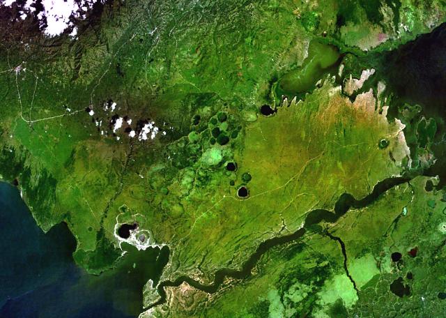
English: Lake-filled and dry maars of the Katwe-Kikorongo volcanic field occupy the center of this NASA Landsat image (with north to the top). The volcanic field lies above the river channel connecting Lake Edward (lower left) with Lake George (upper right) in the Western Rift Valley of Uganda. Oblong, dark-colored Lake Katwe (lower left) is a shallow 3-km-long body of water that occupies two of three intersecting craters immediately NE of Lake Edward. Local folk tales suggest that volcanism in the Katwe-Kikorongo area has continued into historical times.
Час створення Невідома дата
Джерело http://www.volcano.si.edu/world/volcano.cfm?vnum=0203-003&volpage=photos&photo=114093
Автор NASA Landsat7 image (worldwind.arc.nasa.gov)

Ліцензування

Public domain
This image is in the public domain because it is a screenshot from NASA’s globe software World Wind using a public domain layer, such as Blue Marble, MODIS, Landsat, SRTM, USGS or GLOBE.

العربيَّة | English | فارسی | français | עברית | македонски | മലയാളം | Nederlands | русский | 中文(中国大陆)‎ | +/−

Підписи

Додайте однорядкове пояснення, що саме репрезентує цей файл

Об'єкти, показані на цьому файлі

зображує

Історія файлу

Клацніть на дату/час, щоб переглянути, як тоді виглядав файл.

Дата/часМініатюраРозмір об'єктаКористувачКоментар
поточний21:38, 1 листопада 2010Мініатюра для версії від 21:38, 1 листопада 2010640 × 456 (67 КБ)Michael Metzger{{Information |Description={{en|1=Lake-filled and dry maars of the Katwe-Kikorongo volcanic field occupy the center of this NASA Landsat image (with north to the top). The volcanic field lies above the river channel connecting Lake Edward (lower left) wit

Така сторінка використовує цей файл:

Глобальне використання файлу

Цей файл використовують такі інші вікі:

Метадані