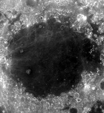
Файл:Mare Crisium - Clementine.jpg
Mare_Crisium_-_Clementine.jpg (350 × 382 пікселів, розмір файлу: 17 КБ, MIME-тип: image/jpeg)
Історія файлу
Клацніть на дату/час, щоб переглянути, як тоді виглядав файл.
| Дата/час | Мініатюра | Розмір об'єкта | Користувач | Коментар | |
|---|---|---|---|---|---|
| поточний | 00:36, 1 червня 2007 |  | 350 × 382 (17 КБ) | Bryan Derksen | {{Information |Description={{en|en:Mare Crisium, also known as the "Sea of Crisis", is located in the Crisium basin, just northeast of Mare Tranquillitatis. This basin is of the Nectarian epoch, while the mare material is of the Upper Imbrian epoc |
Використання файлу
Така сторінка використовує цей файл:
Глобальне використання файлу
Цей файл використовують такі інші вікі:
- Використання в ar.wiki.x.io
- Використання в be.wiki.x.io
- Використання в bg.wiki.x.io
- Використання в ca.wiki.x.io
- Використання в cs.wiki.x.io
- Використання в de.wiki.x.io
- Використання в el.wiki.x.io
- Використання в es.wiki.x.io
- Використання в fi.wiki.x.io
- Використання в fr.wiki.x.io
- Mare Crisium
- Discussion:Mare Crisium
- Utilisateur:Shonagon/Sur la Lune
- Wikipédia:Statistiques des anecdotes de la page d'accueil/Visibilité des anecdotes (2018)
- Discussion:Mer des Crises/LSV 16306
- Wikipédia:Statistiques des anecdotes de la page d'accueil/Visibilité des anecdotes (2018)/2018 12
- Projet:Aide et accueil/Twitter/Tweets/archives/décembre 2018
- Wikipédia:Le saviez-vous ?/Archives/2018
- Використання в he.wiki.x.io
- Використання в hy.wiki.x.io
- Використання в id.wiki.x.io
- Використання в it.wiki.x.io
- Використання в ka.wiki.x.io
- Використання в ko.wiki.x.io
- Використання в lb.wiki.x.io
- Використання в lv.wiki.x.io
- Використання в nl.wiki.x.io
- Використання в no.wiki.x.io
- Використання в pl.wiki.x.io
- Використання в pt.wiki.x.io
- Використання в ru.wiki.x.io
- Використання в sr.wiki.x.io
- Використання в vi.wiki.x.io
- Використання в www.wikidata.org
- Використання в zh-min-nan.wiki.x.io


