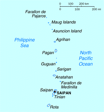
Файл:Northern Mariana Islands map.gif
Northern_Mariana_Islands_map.gif (345 × 371 пікселів, розмір файлу: 24 КБ, MIME-тип: image/gif)
Історія файлу
Клацніть на дату/час, щоб переглянути, як тоді виглядав файл.
| Дата/час | Мініатюра | Розмір об'єкта | Користувач | Коментар | |
|---|---|---|---|---|---|
| поточний | 03:17, 18 серпня 2010 |  | 345 × 371 (24 КБ) | Ras67 | cropped |
| 00:24, 17 травня 2008 |  | 351 × 377 (25 КБ) | Scanlan | {{Information |Description=Map of the Northern Mariana Islands |Source=http://www.doi.gov/oia/Islandpages/cnmipage.htm |Date= |Author=United States Department of the Interior |Permission= |other_versions= }} [[Category:Maps of the Northern Marian |
Використання файлу
Така сторінка використовує цей файл:
Глобальне використання файлу
Цей файл використовують такі інші вікі:
- Використання в af.wiki.x.io
- Використання в ar.wiki.x.io
- Використання в ast.wiki.x.io
- Використання в be-tarask.wiki.x.io
- Використання в bn.wiki.x.io
- Використання в ch.wiki.x.io
- Використання в cs.wiki.x.io
- Використання в cy.wiki.x.io
- Використання в da.wiki.x.io
- Використання в en.wiki.x.io
- Northern Mariana Islands
- Geography of the Northern Mariana Islands
- List of state and territory name etymologies of the United States
- List of regions of the United States
- Territories of the United States
- 2008 United States House of Representatives election in Northern Mariana Islands
- User:Falcaorib/Canada, United States and Mexico
- Використання в es.wiki.x.io
- Використання в fa.wiki.x.io
- Використання в fr.wiki.x.io
- Використання в he.wiki.x.io
- Використання в id.wiki.x.io
- Використання в incubator.wikimedia.org
- Використання в io.wiki.x.io
- Використання в ja.wiki.x.io
- Використання в ka.wiki.x.io
- Використання в ko.wiki.x.io
- Використання в ml.wiki.x.io
- Використання в mr.wiki.x.io
- Використання в pt.wiki.x.io
- Використання в ru.wiki.x.io
- Використання в ta.wiki.x.io
- Використання в to.wiki.x.io
- Використання в tr.wiktionary.org
- Використання в tt.wiki.x.io
- Використання в zh.wiki.x.io

