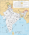
Файл:Political map of India EN.svg

Розмір цього попереднього перегляду PNG для вихідного SVG-файлу: 511 × 599 пікселів. Інші роздільності: 205 × 240 пікселів | 410 × 480 пікселів | 655 × 768 пікселів | 874 × 1024 пікселів | 1748 × 2048 пікселів | 1594 × 1868 пікселів.
Повна роздільність (SVG-файл, номінально 1594 × 1868 пікселів, розмір файлу: 337 КБ)
Історія файлу
Клацніть на дату/час, щоб переглянути, як тоді виглядав файл.
| Дата/час | Мініатюра | Розмір об'єкта | Користувач | Коментар | |
|---|---|---|---|---|---|
| поточний | 22:37, 25 травня 2024 |  | 1594 × 1868 (337 КБ) | Gegot | File uploaded using svgtranslate tool (https://svgtranslate.toolforge.org/). Added translation for de. |
| 16:48, 25 травня 2024 |  | 1594 × 1868 (337 КБ) | Gegot | File uploaded using svgtranslate tool (https://svgtranslate.toolforge.org/). Added translation for de. | |
| 13:49, 28 вересня 2022 |  | 1594 × 1868 (325 КБ) | ऐक्टिवेटेड् | File uploaded using svgtranslate tool (https://svgtranslate.toolforge.org/). Added translation for sa. | |
| 19:30, 27 серпня 2022 |  | 1594 × 1868 (312 КБ) | Johano | File uploaded using svgtranslate tool (https://svgtranslate.toolforge.org/). Added translation for eo. | |
| 22:34, 23 серпня 2022 |  | 1594 × 1868 (310 КБ) | Johano | File uploaded using svgtranslate tool (https://svgtranslate.toolforge.org/). Added translation for eo. | |
| 05:30, 3 липня 2020 |  | 1594 × 1868 (300 КБ) | Jfblanc | removed I-mark and replaced by H (thanks Wassermaus!) | |
| 15:56, 7 квітня 2020 |  | 1594 × 1868 (299 КБ) | Jfblanc | Merger of UTs of Dadra & Nagar Haveli with Daman and Diu (26 January 2020). | |
| 07:47, 19 листопада 2019 |  | 1594 × 1868 (293 КБ) | Getsnoopy | Complete code overhaul for easier manipulation. Corrected JK and Ladakh border in PaK. Adjusted some label positions and some other styles. | |
| 20:12, 8 листопада 2019 |  | 1594 × 1868 (318 КБ) | Getsnoopy | Reverted to version as of 14:11, 2 November 2019 (UTC) | |
| 20:10, 8 листопада 2019 |  | 1594 × 1868 (291 КБ) | Getsnoopy | Complete code overhaul for easier manipulation. Corrected JK and Ladakh border in PaK. Adjusted some label positions and some other styles. |
Використання файлу
Такі сторінки використовують цей файл:
Глобальне використання файлу
Цей файл використовують такі інші вікі:
- Використання в ace.wiki.x.io
- Використання в as.wiki.x.io
- Використання в bat-smg.wiki.x.io
- Використання в be-tarask.wiki.x.io
- Використання в bh.wiki.x.io
- Використання в bn.wiki.x.io
- Використання в bs.wiki.x.io
- Використання в cs.wiki.x.io
- Використання в da.wiki.x.io
- Використання в en.wiki.x.io
- India
- Central Reserve Police Force
- List of Indian state and union territory name etymologies
- Outline of India
- Talk:States of India
- Template:Indian states and territories image map
- User:RajatTikmany
- User:Srujan1001/sandbox
- User:RexxS/India (no clear)
- User:RexxS/India (20em cols)
- User:RexxS/India (15em cols)
- User:Berek/India
- Talk:India/Archive 46
- User:Fowler&fowler/India
- Використання в eo.wiki.x.io
- Використання в es.wiki.x.io
- Використання в fi.wiki.x.io
- Використання в fr.wiki.x.io
- Використання в gl.wiki.x.io
- Використання в he.wiki.x.io
Переглянути сторінку глобального використання цього файлу.
