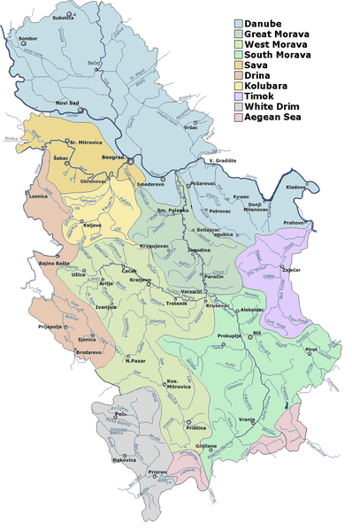
Файл:Serbia drainage basins detailed.png

Розмір при попередньому перегляді: 398 × 599 пікселів. Інші роздільності: 159 × 240 пікселів | 319 × 480 пікселів | 850 × 1280 пікселів.
Повна роздільність (850 × 1280 пікселів, розмір файлу: 317 КБ, MIME-тип: image/png)
Історія файлу
Клацніть на дату/час, щоб переглянути, як тоді виглядав файл.
| Дата/час | Мініатюра | Розмір об'єкта | Користувач | Коментар | |
|---|---|---|---|---|---|
| поточний | 12:01, 6 листопада 2006 |  | 850 × 1280 (317 КБ) | Duja | ==Description== Detailed map of rivers and main drainage basins in Serbia ==Licensing== Merged from several images published by Hydrometeorological Institute of Serbia , http://www.hidmet.sr.gov.yu/slike_lat/kv_vode/ [[Category:Maps of rivers of Serbia |
Використання файлу
Така сторінка використовує цей файл:
Глобальне використання файлу
Цей файл використовують такі інші вікі:
- Використання в ast.wiki.x.io
- Використання в bg.wiki.x.io
- Використання в bn.wiki.x.io
- Використання в cs.wiki.x.io
- Використання в de.wiki.x.io
- Використання в en.wiki.x.io
- Використання в es.wiki.x.io
- Використання в fr.wiki.x.io
- Використання в it.wiki.x.io
- Використання в mk.wiki.x.io
- Використання в nl.wiki.x.io
- Використання в nn.wiki.x.io
- Використання в pl.wiki.x.io
- Використання в ro.wiki.x.io
- Використання в ru.wiki.x.io
- Використання в sh.wiki.x.io
- Використання в sr.wiki.x.io
- Јадар (притока Дрине)
- Списак река у Србији
- Јабланица (притока Јужне Мораве)
- Јадар (област)
- Рибница (притока Ибра)
- Лопатањка (река)
- Рибница (притока Колубаре)
- Фидер риболов
- Бешеновачки поток
- Бруја (водени ток)
- Велики поток
- Врањашки поток
- Думбовачки поток
- Ешиковачки поток
- Јеленце
- Каменарски поток
- Каменички поток
- Козарски поток
- Корушка (водени ток)
- Липовачки поток
- Међеш
Переглянути сторінку глобального використання цього файлу.
